|
Wave Propagation in Volcanoes
|
3-D Seismic Wave Propagation
on a Global and Regional Scale:
Earthquakes, Fault
Zones, Volcanoes
Project Leader: Prof. Dr.
Heiner Igel, Institute of Geophysics, Ludwig-Maximilians-University, Munich
Involved scientists: Gunnar
Jahnke, Michael Ewald, Johannes Ripperger, Tarje Nissen-Meyer, Max Strasser,
Melanie Reichardt, Markus
Treml, Guoquan Wang, Gilbert Brietzke, Miko Fohrmann, Falko Bethmann
|
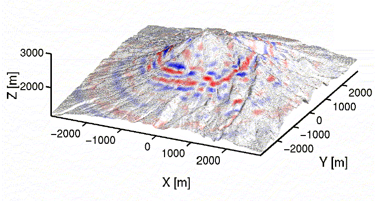
Summary The accurate simulation of seismic wave propagation through realistic 3-D Earth models plays a fundamental role in several areas of geophysics: (1) in global seismology knowledge of the structure of the Earth’s deep interior is crucial to understand the dynamic behaviour of our planet such as mantle convection, slab subduction or hot spot activity. Accurate synthetic 3-D seismograms which can be compared with globally recorded data require a numerical approach. The structural resolution of today’s tomographic models can only be improved by exploiting the 3-D wave effects of the geodynamically important regions inside the Earth. (2) As deterministic earthquake fore-casting seems out of sight, the accurate prediction of likely ground motion following earthquakes in seismically active regions is a major goal which will allow measures (e.g. applying strict building codes) to be taken before major events. 3-D modelling will allow local (e.g. amplifying) effects such as low-velocity zone or topography to be studied. These so-called site effects will be investigated for several areas at risk (e.g. San Francisco Bay Area). (3) Active volcanic areas show very characteristic complex ground motion which is usually recorded on local networks monitoring the activity and risk of eruption. The origin of the seismically recorded signals are poorly understood. One of the reasons is the structural complexity of volcanic areas with strong 3-D heterogeneities, topography and sources in the summit region. Realistic 3-D structures and topography will be studied for two particular regions (Merapi, Indonesia and Mount Vesuvius, Italy). Synthetic seismograms will be calculated and compared with observed data from ongoing field projects. The ultimate goal is to detect reliable precursory signals to volcanic eruptions which will allow early warning of endangered regions. For information on the various ongoing projects please consult the Homepages of the Institute of Geophysics at the Ludwig-Maximilians-University of Munich. Several results of simulations and a brief description of the scientifc rationale are given below. |
|
Wave Propagation in Volcanoes
|
|
Simulations of ground motion for likely earthquake scenarios
|
|
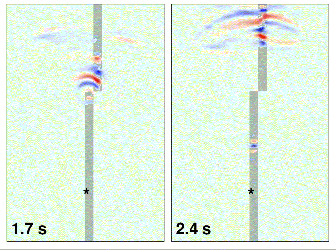
Wave Propagation in Fault Zones
Fault
zones (FZ) are though to consist of a highly localized damage zone with
low seismic velocity and high attenuation. The structure of FZs at depth
has important implications for the size of (future) earthquakes and the
dynamic behaviour of the rupture. Only recently it was observed that right
above FZs a particular wave type (guided waves) can be observed which may
allow imaging FZs at depth. Numerical simulations play an important role
in developing imaging schemes and assess their reliability. One of the
main questions we addressed was, whether disrupted faults will allow guided
waves to propagate. (Gunnar, Jahnke, Miko Fohrmann, Yehuda Ben-Zion)
|
|
Wave Propagation in Subduction Zones
Subduction
zones contain the largest earthquakes on Earth. Knowledge of there structural
details not only is important for hazard assessment but also to understand
the dynamics of subduction and mantle convection. In this project a 3D
algorithm in spherical coordinates was implemented and earthquakes in subduction
zones simulated. We were able to simulate particular wave effects observed
in nature which – in the future – can be used to further constrain the
structure of subduction zones. (Tarje Nissen-Meyer, Diplom Thesis, 2001)
|